The Smog Over Jakarta
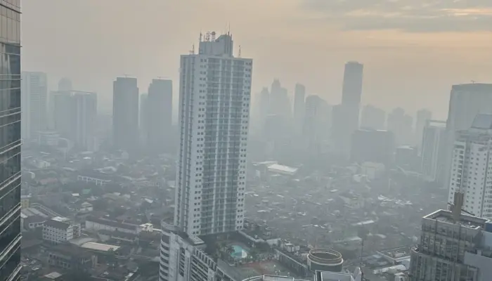
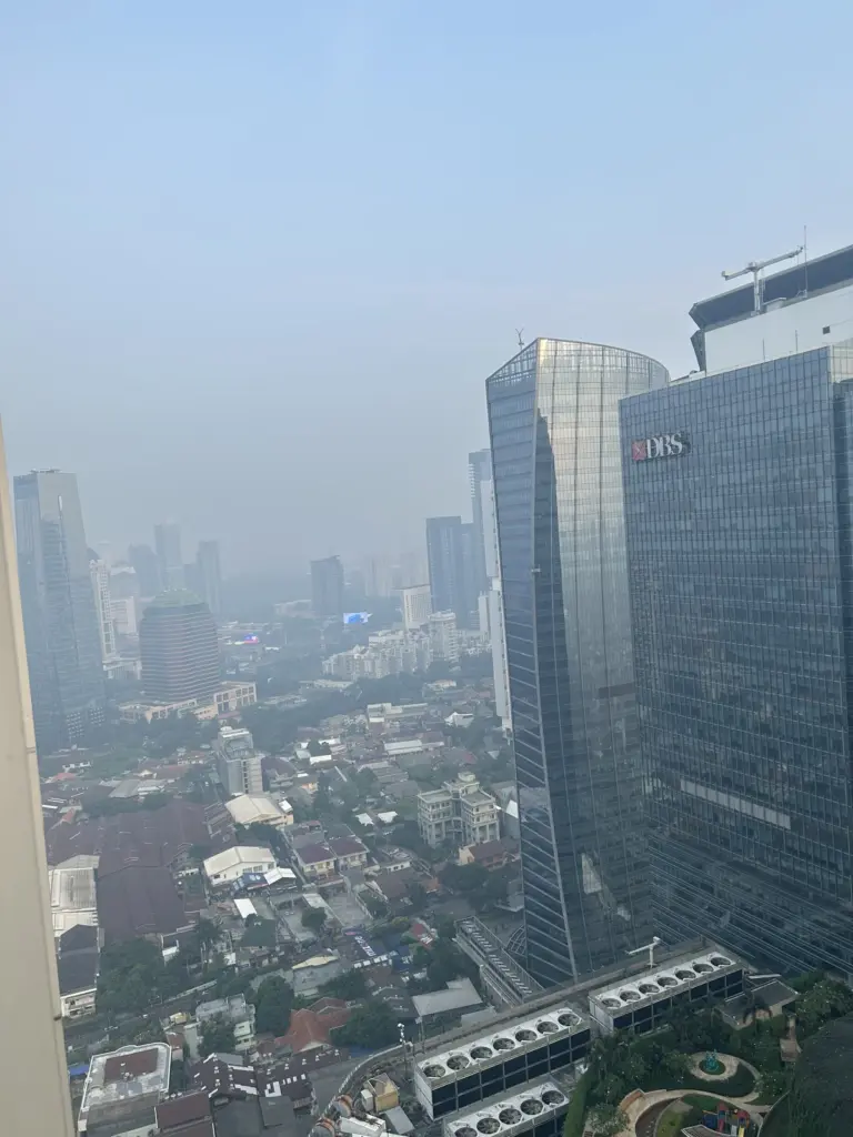
This morning, Jakarta’s skyline was barely visible through a thick, gray haze—a visual testament to the city’s ongoing battle with air pollution. Residents in areas like Kuningan woke up to an AQI of 216 (Very Unhealthy), with PM2.5 levels soaring to 141.0 µg/m³—far above the World Health Organization’s (WHO) recommended annual guideline of 15 µg/m³. The situation was particularly severe in South Jakarta, where AQI readings consistently ranked among the highest in the city.
—
Why Is South Jakarta’s AQI So High?
—
1. Meteorological Conditions: The Perfect Storm for Pollution
Jakarta’s air quality deteriorates dramatically during the dry season (May–October), when low humidity, high temperatures, and weak winds trap pollutants close to the ground. The planetary boundary layer—the lowest part of the atmosphere—thins in the evening, further concentrating emissions from traffic, industries, and other sources. This effect is amplified in South Jakarta, where the city’s topography and urban density can create “pollution pockets”.
- Lack of Rain: May is typically a transitional month between the wet and dry seasons. With minimal rainfall, pollutants like PM2.5 are not washed out of the atmosphere.
- Temperature Inversion: Cooler air near the ground can get trapped under warmer air above, acting like a lid that prevents pollutants from dispersing.
—
2. Traffic: The Invisible Killer
Jakarta’s 10+ million vehicles are a major source of PM2.5. During rush hours, emissions from cars, motorcycles, and trucks spike, and the lack of wind means these pollutants linger. South Jakarta, with its dense residential areas and major roads like Jalan Sudirman and Jalan Rasuna Said, bears the brunt of this traffic-related pollution.
—
3. Industrial Emissions: The Hidden Culprits
While there are no coal plants directly in South Jakarta, the city is surrounded by industrial zones and power plants that contribute to its air pollution:
- Suralaya Coal Power Plant (Banten): Located ~100 km west of Jakarta, this Southeast Asia’s largest coal complex (with multiple units) is a known major polluter. Its emissions can drift toward Jakarta, especially under westerly winds.
- Factories in Tangerang and Bogor: Industrial areas to the west and south of Jakarta release pollutants that can be carried into the city by wind.
- Waste Burning: Open burning of garbage—both residential and industrial—is a common practice in Jakarta’s outskirts, adding to the PM2.5 load.
—
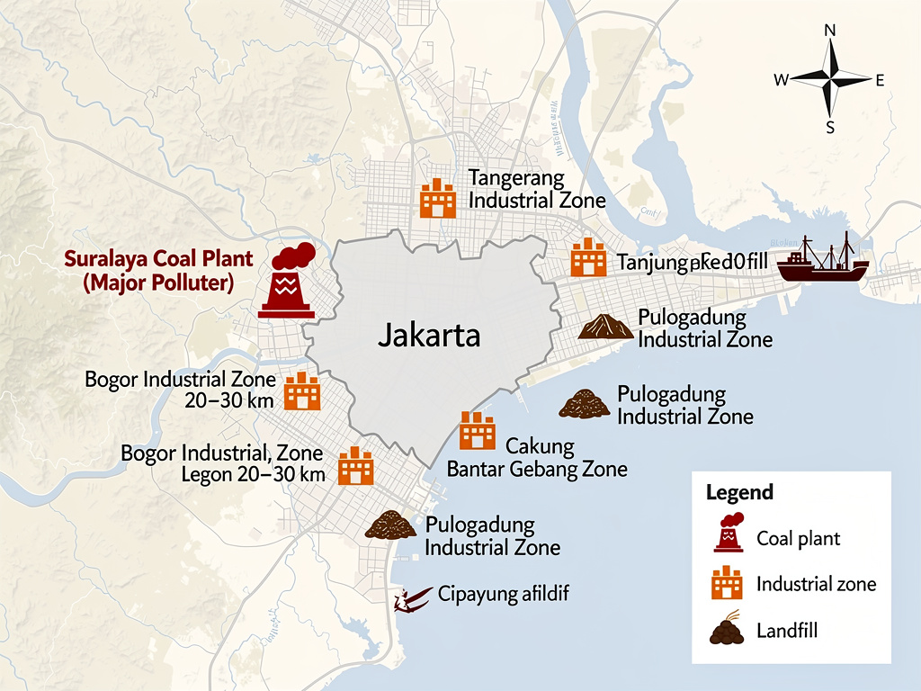
Map of Pollution Sources Relative to Jakarta
—
Major Pollution Sources in and Around Jakarta
—
Coal-Fired Power Plants Affecting Jakarta
These are the biggest industrial emitters affecting Jakarta, especially under westerly or southerly winds.
| Name | Location | Distance from Jakarta | Capacity | Impact on Jakarta | Notes |
|---|---|---|---|---|---|
| Suralaya Power Station | Cilegon, Banten | ~100 km west | 4,025 MW (9 units) | High | Southeast Asia’s largest coal complex; emissions drift eastward to Jakarta under westerly winds. Major source of SO₂, NOₓ, and PM2.5. |
| Cilegon Power Plant | Cilegon, Banten | ~100 km west | 600 MW | High | Part of the Suralaya complex; contributes to regional haze. |
| Lontar Power Plant | Serang, Banten | ~80 km west | 600 MW | Moderate | Coal-fired; emissions can reach Jakarta under certain wind patterns. |
| Cirebon Power Plant | Cirebon, West Java | ~200 km east | 1,000 MW | Low-Moderate | Farther away, but emissions may still impact Jakarta during easterly winds. |
| Paiton Power Plant | Probolinggo, East Java | ~700 km east | 6,600 MW | Minimal | Too far to directly affect Jakarta, but part of Indonesia’s coal-heavy grid. |
Key Insight: Suralaya (Banten) is the primary coal plant affecting Jakarta. Its emissions are blown into the city when winds come from the west or southwest, which is common during the dry season (May–October). No coal plants are located within Jakarta city limits, but the city is surrounded by industrial zones in Banten, West Java, and Bogor.
—
Industrial Zones Contributing to Jakarta’s Air Pollution
These areas contribute PM2.5, NOₓ, and SO₂ from manufacturing, waste burning, and heavy industry.
| Industrial Zone | Location | Distance from Jakarta | Key Polluters | Impact on Jakarta | Notes |
|---|---|---|---|---|---|
| Tangerang Industrial Zone | Tangerang, Banten | ~20–30 km west | Textiles, chemicals, metal processing | High | Dense cluster of factories; emissions drift into West/South Jakarta. |
| Bogor Industrial Zone | Bogor, West Java | ~50 km south | Automotive, electronics, food processing | Moderate-High | South Jakarta is downwind of Bogor during southerly winds. |
| Cikampek Industrial Zone | Karawang, West Java | ~50 km east | Automotive (Toyota, Honda), steel | Moderate | Emissions can reach East Jakarta. |
| Pulogadung Industrial Zone | East Jakarta | Within city limits | Textiles, chemicals, plastics | High | One of Jakarta’s oldest industrial areas; major local source of pollution. |
| Cakung Industrial Zone | East Jakarta | Within city limits | Manufacturing, warehouses | Moderate | Contributes to local air quality degradation. |
| Kawasan Berikat Nusantara (KBN) Cakung | East Jakarta | Within city limits | Electronics, logistics | Moderate | Free trade zone with heavy industrial activity. |
| Tanjung Priok Port | North Jakarta | Within city limits | Shipping, fuel storage, logistics | Moderate | Emissions from ships, trucks, and port operations. |
Key Insight: Tangerang and Bogor are the biggest external industrial contributors to Jakarta’s PM2.5, especially for South and West Jakarta. Pulogadung and Cakung (in East Jakarta) are major local sources of industrial pollution.
—
Traffic and Transportation: Major Pollution Sources in Jakarta
| Area | Key Roads | Impact on Jakarta | Notes |
|---|---|---|---|
| South Jakarta | Jalan Sudirman, Jalan Rasuna Said | Very High | Dense traffic during rush hours; “pollution pockets” form due to urban canyons (tall buildings). |
| Central Jakarta | Jalan Thamrin, Jalan MH Thamrin | Very High | High vehicle density; emissions trapped by buildings. |
| West Jakarta | Jalan S. Parman, Toll Roads | High | Heavy traffic from Tangerang and industrial zones. |
| East Jakarta | Jalan I Gusti Ngurah Rai | High | Congestion from Cakung/Pulogadung industrial zones. |
Key Insight: South Jakarta (e.g., Kuningan, SCBD) has higher PM2.5 than Central Jakarta due to its dense traffic and urban layout, which traps pollutants in “canyons” between tall buildings.
—
The Health Impact: A Silent Emergency
Prolonged exposure to PM2.5 (particulate matter smaller than 2.5 micrometers) is linked to:
- Respiratory diseases (asthma, bronchitis, lung cancer)
- Cardiovascular issues (heart attacks, strokes)
- Premature deaths (Greenpeace estimates 7,390 early deaths annually in Jakarta due to PM2.5).
Children, the elderly, and those with pre-existing conditions are at the highest risk. The WHO’s guideline for safe PM2.5 exposure is 15 µg/m³ annually, but Jakarta’s levels often exceed 100 µg/m³ during peak pollution events.
—
What Can Be Done?
Jakarta’s air pollution crisis requires multi-sector action:
- Stricter Emissions Controls: Enforcing Euro 4/6 standards for vehicles and industries.
- Public Transport Expansion: Reducing reliance on private cars through better bus, MRT, and LRT networks.
- Phasing Out Coal: Accelerating the retirement of coal plants like Suralaya and transitioning to renewables.
- Waste Management Reforms: Banning open burning and improving recycling programs.
- Green Spaces: Increasing urban forests and parks to absorb pollutants.
—
Real-Time Data: Snapshots of May 9, 2026
Below are real-time AQI readings from Kuningan, Jakarta, recorded on May 9, 2026, showing the rapid deterioration of air quality in the early morning hours.
| Location | AQI | Main Pollutant | PM2.5 (µg/m³) | Temperature | Wind | Humidity |
|---|---|---|---|---|---|---|
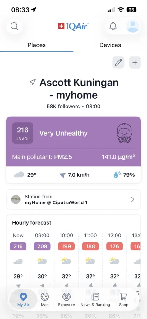
| Kuningan, Jakarta (8:00 AM) | 217 (Very Unhealthy) | PM2.5 | 141.0 | 29°C | 7.0 km/h | 79% |
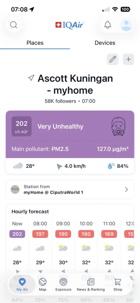
| Kuningan, Jakarta (7:00 AM) | 202 (Very Unhealthy) | PM2.5 | 127.0 | 28°C | 4.0 km/h | 84% |
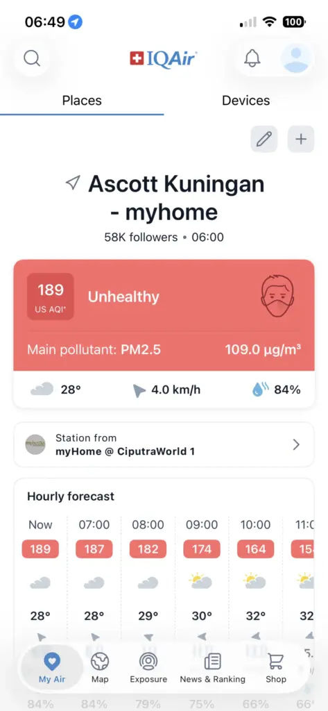
| Kuningan, Jakarta (6:00 AM) | 189 (Unhealthy) | PM2.5 | 109.0 | 28°C | 4.0 km/h | 84% |
—
Sources and Further Reading
- WRI Indonesia: 7 Things to Know About Jakarta’s Air Pollution Crisis
- Lowy Institute: Jakarta’s Air Quality Kills Its Residents – And It’s Getting Worse
- Global Energy Monitor: Banten Suralaya Power Station
- Earth Island Journal: Indonesian Village with Seven Coal Plants Resists Arrival of Two More
- AQICN: Real-Time Jakarta Air Quality Data
- IQAir: Indonesia Air Quality Index
- AAQR: Causality Analysis of Air Quality and Meteorological Parameters for PM2.5 Characteristics in Jakarta
Leave a Reply